


available on the
Google Play
Learn how a licensed surveyor protects your investment, prevents fraud, and ensures a smooth property transaction. Read more.
You have found the perfect piece of land. The price is right. The location is great. You are ready to pay.
But wait. How do you know the beacons are in the right place? How do you know the land actually matches the title deed?
This is where a land surveyor becomes your best friend.
In Kenya, land is more than just soil. It is wealth, security, and your family’s future. But land fraud and boundary disputes are common. A licensed land surveyor helps you avoid these problems.
At Nyotanjema Real Estate, we always advise our clients to involve a surveyor early. It saves money, time, and stress.
Confused about land beacons, boundaries, or survey costs in Kenya? Let us explain exactly what surveyors do and why you need one.

A land surveyor is a trained and licensed professional who measures and maps land. They are the official experts when it comes to property boundaries .
In Kenya, surveyors are regulated by the Land Surveyors’ Board (LSB) . This board is established under the Survey Act (Cap. 299) . Its job is to oversee the profession and make sure only qualified people practice.
If a surveyor is licensed, it means the government trusts their work. Always ask for proof of their license.
Kenya has a complex land history. There are issues like land grabbing, “parallel registers,” and forged title deeds. A surveyor helps you navigate this.
Here are the key reasons you need one:
Sometimes, sellers try to trick buyers. They might show you one piece of land but sell you a different one.
A surveyor visits the site and verifies that the physical land matches the details on the title deed. They check the plot number and the land reference number. This stops fraud before it starts.
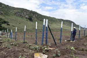
Land beacons are the physical markers on your land. Over time, they can disappear or be moved .
A surveyor will find the original beacons or place new ones. This process is called demarcation. It confirms the exact size and shape of your plot. It also shows if a neighbor has built on your land or if your land has become part of a road.
Did you know? Tampering with land beacons is a criminal offence in Kenya.
A surveyor can tell if part of your land falls on a road reserve, a riparian reserve (near a river), or a protected area. If it does, you cannot build there. This information is vital before you buy .
Can you actually reach your land? A surveyor checks if the access road is a legally recognized public road. Without this, you might buy land you cannot get to.
A wayleave is a right given to third parties (like Kenya Power or water companies) to use a part of your land for cables or pipes. This can stop you from building in certain areas. A surveyor will identify these restrictions for you.
If you buy a large plot and want to sell part of it, you must go through the land subdivision process in Kenya. A surveyor prepares the necessary maps and mutations to create new, separate title deeds .
Different situations need different surveys. Here are the most common ones:
| Type of Survey | What It Does |
|---|---|
| Boundary / Fixed Boundary Survey | Establishes or re-establishes the exact boundaries of a property. Confirms beacon positions . |
| Topographical Survey | Maps the land’s features: hills, valleys, rivers, trees, and existing buildings. Needed for construction planning . |
| Subdivision Survey (Mutation) | Divides one large plot into smaller, separate parcels. Creates new title deeds . |
| Geomatic / GIS Survey | Uses digital technology (GPS) to create highly accurate maps and data for large areas. |
| Sectional Survey | For apartments or flats. It defines the boundaries of individual units within a building . |
| Construction / Architectural Survey | Provides exact measurements for builders to follow. Ensures the house is built in the right place. |

What happens when you hire a surveyor? Here is the typical process for a boundary survey :
Find a surveyor registered with the Institution of Surveyors of Kenya (ISK) . We at Nyotanjema can connect you with trusted professionals.
You will need to give the surveyor:
Copy of the title deed.
Copy of your ID or passport.
Land search results (to confirm ownership).
The Registry Index Map (RIM) or Field Reference Map (FR) for the area .
The surveyor goes to the Survey of Kenya office to get the official maps. These show the exact coordinates of your land as recorded by the government .
The surveyor visits your land. They use tools like GPS and Total Stations to find the beacons. If beacons are missing, they place new ones using concrete or iron marks .
The surveyor tells your neighbors about the survey. They are invited to attend. This prevents future arguments. If they don’t come, a witness (like a local assistant chief) can stand in.
The surveyor prepares a report and a map. If everything is correct, they can issue a Beacon Certificate. This is a legally binding document that proves your boundaries .
If the survey created new boundaries (like in a subdivision), the surveyor prepares a mutation form. This is submitted to the Ministry of Lands to update the records and get new title deeds .

This is one of the most common questions. The cost varies depending on the land size, location, and type of survey.
Here is a general guide to help you budget. Note that these are estimates and can change .
| Service | Estimated Cost (KES) |
|---|---|
| Consultancy Fees | Ksh 3,000 per hour (Government rate) |
| Basic Map (eCitizen) | 500 – 1,000 |
| Registry Index Map (RIM) | Government: 2,000 – 5,000 / Private: 10,000 – 30,000 |
| Beacon Certificate | Government: 3,000 – 7,000 / Private: 15,000 – 50,000 |
| Boundary (Fixed) Survey | Ksh 20,000 × √(Area in Hectares) + 3% of land value |
| Topographical Survey | Ksh 30,000 per hectare |
| Subdivision Survey | Government: 10,000 – 20,000 / Private: 50,000 – 200,000+ |
| Sectional Survey (per unit) | 20,000 – 35,000 (depending on number of units) |
Factors that affect price:
Land size: Larger parcels cost more.
Location: Remote areas may have higher travel costs for the surveyor.
Terrain: Hilly or forested land is harder to survey.
Urgency: Rush jobs usually cost extra.

It is easy to get confused between a surveyor, a planner, and a lawyer. Here is how they are different:
Land Surveyor: Deals with the physical land. They measure boundaries, place beacons, and create maps.
Physical Planner: Deals with how the land can be used. They check zoning rules (e.g., is it residential or commercial?) and help with subdivision scheme plans.
Real Estate Agent (like Nyotanjema): Helps you find the right property, connects you with professionals, and guides you through the buying process.
Lawyer: Handles the legal documents, contracts, and title deed transfer.
You need all of them for a safe transaction.

Skipping the surveyor might save you a few thousand shillings now. But it can cost you millions later.
Boundary Disputes: You could end up in court with your neighbor for years.
Buying the Wrong Land: You might pay for a plot that doesn’t exist or is in the wrong place.
Building on Public Land: You could construct your dream house only to find it is on a road reserve and must be demolished .
Failed Loan Applications: Banks usually require a survey before they approve a mortgage .
Title Deed Problems: You might struggle to get a title deed in your name if the survey doesn’t match the official records.
In a recent Kenyan court case, titles were canceled because survey documents (Deed Plans) were found to be irregular. This shows how important accurate surveys are to the legal “root of title.”

If you are reading this from the USA, UK, Europe, Saudi Arabia, or Dubai, you face extra challenges. You cannot simply jump in a car and go see the land. You rely on photos, videos, and the word of others.
This makes the role of a surveyor even more critical for you.
When you are thousands of miles away, a surveyor acts as your independent witness. They are a licensed professional with no stake in the sale. They will tell you the truth about the physical condition of the land.
Here is how we at Nyota Njema help diaspora clients use surveyors to stay safe:
We can coordinate a video call with the surveyor while they are on the land. You can watch them:
Locate the beacons in real-time.
Walk the boundaries of your plot.
Show you the access road and neighboring properties.
This is the next best thing to being there yourself.
We will ensure the surveyor issues a Beacon Certificate after the inspection. This document is your proof that the land you paid for is the land that exists. Keep it safe with your title deed.
You need to know if the road to your plot is a public road. You need to know if power lines can reach your land. A surveyor’s topographical survey will answer these questions. This is vital if you plan to build rentals for passive income.
Some sellers might try to sell you land that has disputes. A surveyor will check the physical records at the Survey of Kenya. They will confirm the land is not part of a larger, contested area. This protects you from buying someone else’s problem.
We connect the surveyor’s report with your lawyer’s legal work. The surveyor confirms the physical boundaries. The lawyer confirms the legal ownership. When these two match, your investment is safe.
You can track the progress of the survey and the land buying process through the Nyota App. Download the Nyota App download APK from our website. You will get updates, photos, and reports from the ground straight to your phone.
At Nyotanjema, we understand the fear of buying land from abroad. We are your local partners. We handle the coordination with surveyors, lawyers, and government offices. You do not need to take time off work or buy expensive plane tickets until the deal is done and the title deed is in your name.

Before you buy any land, follow this simple rule:
Find the Land: Work with a trusted agent like Nyotanjema.
Do a Land Search: Verify ownership at the lands registry.
Hire a Licensed Surveyor: Ask them to do a physical inspection and boundary survey.
Get a Beacon Certificate: Keep this document as proof of your boundaries.
Proceed with the Sale: Only pay the balance after the survey is done.
This process protects your investment.

A: Their main role is to measure land and confirm exact boundaries. They make sure the physical land matches the legal documents .
A: You can ask us at Nyotanjema for a referral. You can also check with the Institution of Surveyors of Kenya (ISK) or look for surveyors registered with the Land Surveyors’ Board .
A: Yes. Size doesn’t matter. A survey protects your investment, no matter how small the plot is. It prevents future problems with neighbors.
A: Yes, you can. The surveyor can use the Land Reference Number (LR No.) from a sale agreement or a letter from local authorities .
A: A survey map is valid indefinitely. However, if you subdivide the land or there are changes to boundaries, you will need a new survey .
A: It is a legal document issued by a surveyor. It certifies that the beacons on your land are correctly placed and registered .
A: Costs vary. A boundary survey can start from around Ksh 20,000, but it depends on the land size and location. See the table above for a detailed guide .
A: No, a surveyor cannot remove a caution. A caution (or caveat) is a legal restriction on your title deed. Only the person who placed the caution, or a court order, can remove it. A surveyor deals with physical boundaries, not legal restrictions. You need a lawyer for this .
A: It depends on the size and complexity of the land. A simple boundary survey on a small plot might take 1 to 3 days. Larger or more complex surveys, especially those requiring approval from the Survey of Kenya, can take 1 to 2 weeks or longer .
A: A survey map (like a Registry Index Map) is the master map for an area. It shows many plots together, like a blueprint for a whole neighborhood. A deed plan is a copy of the part of that map that specifically shows your individual plot. It is usually attached to your title deed and shows the exact shape and size of your land .
Buying land is one of the biggest financial decisions you will make. You need a team you can trust.
At Nyotanjema Real Estate, we do more than just list properties. We guide you through the entire process. We connect you with licensed surveyors, verify documents, and ensure you get clean, safe land.
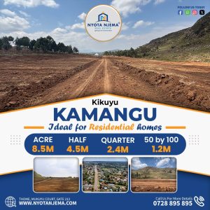
Browse our listings in Kitengela, Juja, Ruiru, Naivasha, and Nanyuki.
Contact our diaspora team for a video tour.
Let us help you build your future.
[Visit Nyotanjema.com Today]